
Caracas and its surronds plan, 1934. Drawn by Eduardo Röhl. Comercio, Lithography and tipography.HC-41

Caracas’ most beautiful plan
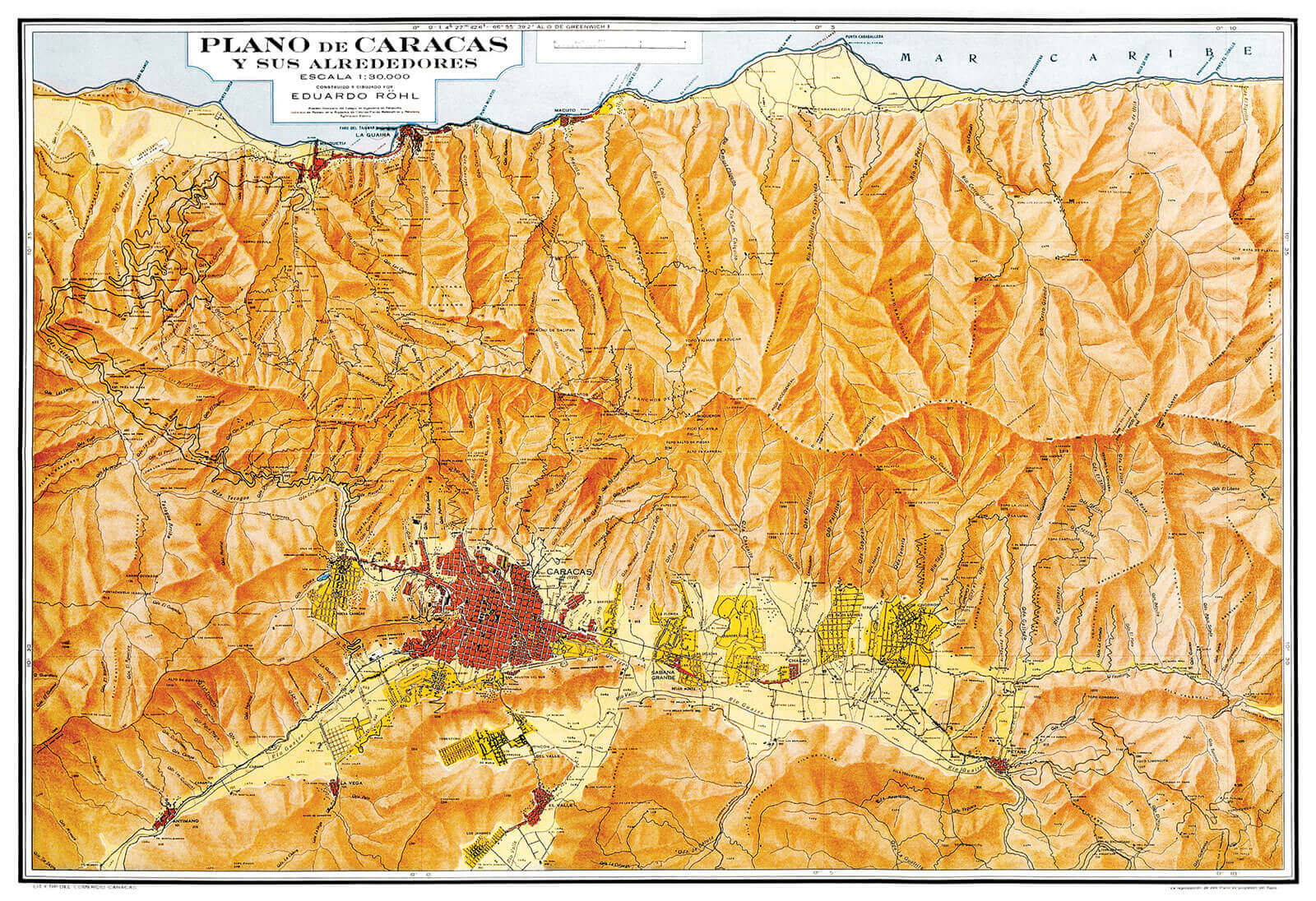
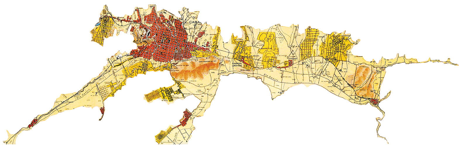
In this 1934 plan, titled «Caracas y sus alrededores» (Caracas and its surroundings), the geography is going to be the main feature. This 96 x 65 centimeter drawing, in ochre, yellow and orange tones, was based on an aerial photograph, and in it we see every mountain and valley of what would be the metropolitan Caracas.
We see how the Colonial city’s checkerboard is circumscribed to a small valley, part of a much greater system in which there are towns on the verge of being encompassed, new neighborhoods with dissimilar grids, and most of all, ample fields of land waiting to be conquered. The plan exalts the geography, the accidents, the reliefs and windings, to the point that the different heights in the topography are the matter pointed out with the greatest diligence. If we return to my father’s sentence: «A city attacked by its inhabitants and defended by its topography», we find here a celebration of the natural bastion defending Caracas.
Once again, one must talk about map and plan. In a 1:30.000 scale, the valley system down to the Caribbean coast is covered. In this colossal geographical context, a horse seems to be drawn resting against El Ávila with its snout biting Catia, and the pathway into La Guaira coming from between its ears. While one leg stretches along the west, accompanied by the river Guaire’s course, and the hoof steps on Antímano; another leg makes way into the valley, joined by the same river. Of its back legs we see very little, the plan fails to offer most of the southeastern areas, which were still to be developed; it seems that Röhl never foresaw a growth towards that direction. The noble horse has Petare in its testicles and Bolívar Square and the colonial grid lodged in its heart; its tail looks onto Guarenas, and in his stomach lays Los Caobos Park.
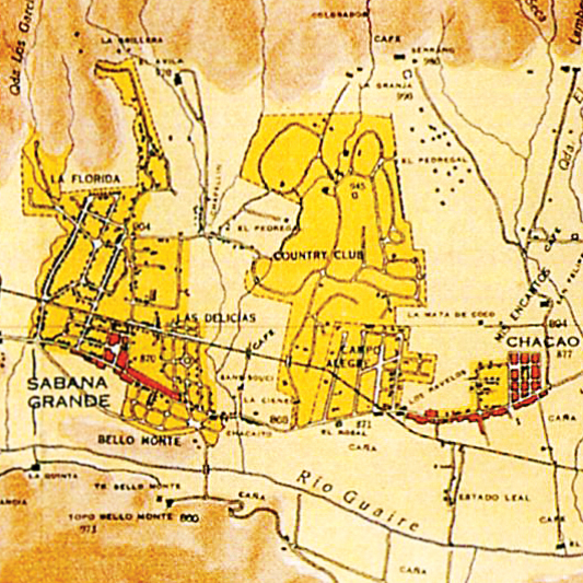
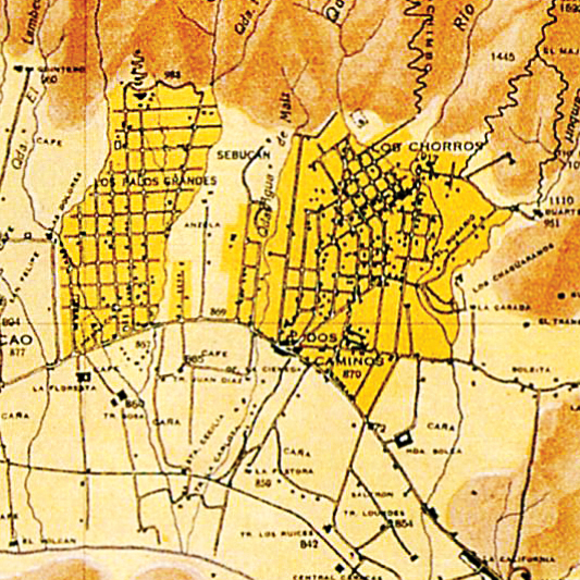
Between the relief of mountains and hills, most of the valley lands are in blank, like an emptiness waiting for urban conquering. The downtown colonial nucleus and towns with colonial origins, such as Petare and Chacao, are marked in orange; while XIX-XX century developments and new neighborhoods to the East, such as Los Caobos, La Florida, El Country Club, Campo Alegre, Palos Grandes, and Sebucán, are marked in yellow, highlighting their isolated buildings. This plan reveals the rising tendency to conquer the East. Urban developers such as Luis Roche and Juan Bernardo Arismendi develop new neighborhoods in old farms colliding with Caracas, having in mind an intention to forever border the city’s center. In these new proposals we see the predomination of the, previously mentioned, «Isolated family homes». The communication between this new urbanism is not strategized; we see how the north-south brooks, that defined the limits of the old coffee plantations, are also used to separate the new neighborhoods. They are communicated only by their extreme south, along what would be the Francisco de Miranda avenue. This isolation seems being part of a strategy, of a conscious intention. One is going from a congregated city to a disaggregated one by vocation
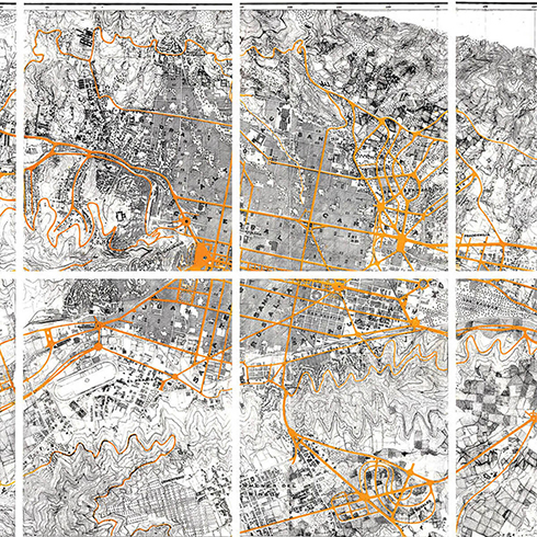
The photographic restitution
This 1936 plan, in a 1:5.000 scale, seems like an approach to Röhl’s previous plan. Drawn by National Cartography by means of a photographic restitution using stereoplanigraph and aerial cartography; in other words aerial photographs converted into topographical plans. The plan’s precision is sufficiently eloquent when it comes to highlighting the differences between what was built-up in the original colonial grid and what was built-up in the surrounding urbanisms. The checkerboard’s compact textures contrast with the atomized textures of the isolated neighborhoods, such as La
Florida. In one case we can see the representation of an urbanism with context; in another we can see a seemingly isolated building which is, in fact, part of a neighborhood. Finally, we can clearly see how urban houses with patios are succeeded by suburban houses with surrounding gardens.
HC-42
HC-42
Caballo-Rohl